An open-source watertight unmanned aerial vehicle for water quality monitoring
@article{Rodrigues2015AnOW,
  title={An open-source watertight unmanned aerial vehicle for water quality monitoring},
  author={Paulo Rodrigues and Francisco Marques and Eduardo Pinto and Ricardo Pombeiro and Andr{\'e} Lourenço and Ricardo Mendonça and Pedro F. Santana and Jos{\'e} Barata},
  journal={OCEANS 2015 - MTS/IEEE Washington},
  year={2015},
  pages={1-6},
  url={https://api.semanticscholar.org/CorpusID:21447216}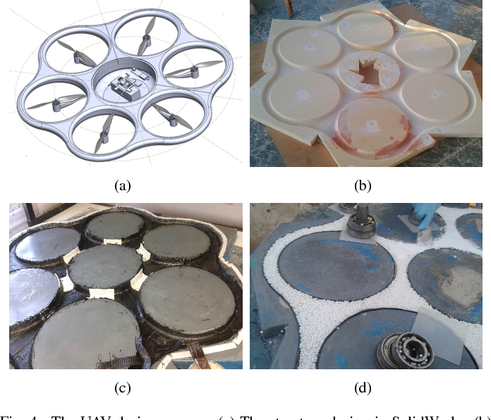
}An open-source watertight multirotor Unmanned Aerial Vehicle capable of vertical takeoff and landing on both solid terrain and water for environmental monitoring and the ability to actively control its on-surface drifting is presented.
Figures from this paper


18 Citations
Energy-Aware Path Planning for Fixed-Wing Seaplane UAVs
- 2023
Environmental Science, Engineering
Fixed-wing unmanned aerial vehicles (UAVs) are commonly used for remote sensing applications over water bodies, such as monitoring water quality or tracking harmful algal blooms. However, there are…
An Overview on Aquatic Unmanned Aerial Vehicles
- 2019
Engineering, Environmental Science
This paper analyzes difficulties in shape design, wing design, cross-domain design, take-off and landing design, etc., and discusses some insightful solutions from the perspectives of AUVs and UAVs.
UAV-Assisted Water Quality Monitoring
- 2020
Environmental Science, Engineering
An unmanned aerial vehicle-assisted water quality measurement system (UAMS) was developed for in situ surface water quality measurement. A custom-built hexacopter was equipped with an open-source…
Viability and performance of a multi-medium unmanned aerial vehicle designed for hydro data acquisition
- 2020
Environmental Science, Engineering
The proposed solution was the use of a multi-medium octo-rotor capable of performing aerial and aquatic missions while retrieving salient hydro data while replacing human involvement with the implementation of a remote platform.
Autonomous In Situ Measurements of Noncontaminant Water Quality Indicators and Sample Collection with a UAV
- 2019
Environmental Science, Engineering
The objective of this research was to conduct in situ measurements of electrical conductivity (EC), pH, dissolved oxygen (DO), and temperature, and collect water samples simultaneously at different…
Conceptualization and Prototyping of Unmanned Amphibious Aerial Vehicle for Water Quality Assessment
- 2019
Environmental Science, Engineering
Unmanned Amphibious Aerial Vehicles (UAAV) are gaining significant interest in accessing remote water bodies and an ideal tool for limnologist in water quality assessment. In this article,…
Thruster Allocation and Mapping of Aerial and Aquatic Modes for a Morphable Multimodal Quadrotor
- 2020
Engineering, Environmental Science
A revised prototype implementing a morphable vehicle structure, where the rotors can be tilted to allow thrust vectoring when underwater, and an appropriate thruster allocation and mapping system that will allow a single user to control the vehicle manually in both aerial and aquatic modes are presented.
Survey on the Development of Aerial-Aquatic Hybrid Vehicles
- 2021
Engineering, Environmental Science
The fundamental challenges associated with aerial–aquatic hybrid locomotion are discussed as well as the necessary trade-offs in design decisions, and the range of solutions that have been adopted to solve the aforementioned challenges are analyzed.
Sensing water properties at precise depths from the air
- 2017
Engineering, Environmental Science
This work presents an Unmanned Aerial Vehicle (UAV) based method of keeping a passive, cable-suspended sensor payload at a precise depth, with 95% of submerged sensor readings within ±8.4 cm of the target depth, helping dramatically increase the spatiotemporal resolution of water science datasets.
DESIGN CONCEPTION AND EVALUATION OF AN UNMANNED AMPHIBIOUS AERIAL VEHICLE USING SYSTEMATIC APPROACH
- 2022
Environmental Science, Engineering
This article’s incitement interprets Unmanned Amphibious Aerial Vehicle (UAAV)’s conceptual design process in a systematic approach. The UAAV is conceptualised to be an ideal tool for limnologists in…
15 References
An autonomous surface vehicle for water quality monitoring
- 2009
Engineering, Environmental Science
This paper describes a novel Autonomous Surface Vehicle capable of navigating throughout complex inland water storages and measuring a range of water quality properties and greenhouse gas emissions.…
An autonomous surface-aerial marsupial robotic team for riverine environmental monitoring: Benefiting from coordinated aerial, underwater, and surface level perception
- 2014
Environmental Science, Engineering
This paper presents RIVERWATCH, an autonomous surface-aerial marsupial robotic team for riverine environmental monitoring, composed of an Autonomous Surface Vehicle piggybacking a multirotor Unmanned Aerial Vehicle with vertical takeoff and landing capabilities.
Survey on the novel hybrid aquatic–aerial amphibious aircraft: Aquatic unmanned aerial vehicle (AquaUAV)
- 2015
Engineering, Environmental Science
Autonomous bathymetry for risk assessment with ROAZ robotic surface vehicle
- 2009
Engineering, Environmental Science
The use of unmanned marine robotic vehicles in bathymetric surveys is discussed. This paper presents recent results in autonomous bathymetric missions with the ROAZ autonomous surface vehicle. In…
Autonomous Aerial Water Sampling
- 2015
Engineering, Environmental Science
It is found that even winds of 5.8 m/s have little impact on the water sampling system and that the samples collected are consistent with traditional techniques for most properties.
AmBot: A Bio-Inspired Amphibious Robot for Monitoring the Swan-Canning Estuary System
- 2014
Environmental Science, Engineering
Finite element analysis (FEA) was applied to optimize the main components of the AmBot for weight reduction without sacrificing functionality and safety, and centipede-inspired tracks were engineered with each track-piece consisting of an aluminum base and a polystyrene-block float.
Remote water sampling using flying robots
- 2014
Engineering, Environmental Science
A system for sampling of water using an unmanned helicopter and integrated into a control framework allowing easy access and control by scientists, in this case biologists, could be acquired reliably.
Mapping Complex Marine Environments with Autonomous Surface Craft
- 2010
Engineering, Environmental Science
Key algorithmic contributions include methods to account for degradation of GPS in close proximity to bridges or foliage canopies and scalable systems for management of large volumes of sensor data to allow for consistent online mapping under limited physical memory.
Analysis of ground effect on multi-rotors
- 2014
Engineering, Physics
Results show that model obtained can be used to counter the ground effect in UAVs, and would also decrease stress on the controller and it will consume less power as it would not have to expend extra power in attempting to stabilize the UAV.
Autonomous River Exploration
- 2013
Engineering, Environmental Science
This work proposes the use of a micro air vehicle flying under the canopy to create accurate maps of the environment and presents an algorithm that can guide the vehicle based upon local sensors mounted on board the flying vehicle that can perceive the river, bank and obstacles.